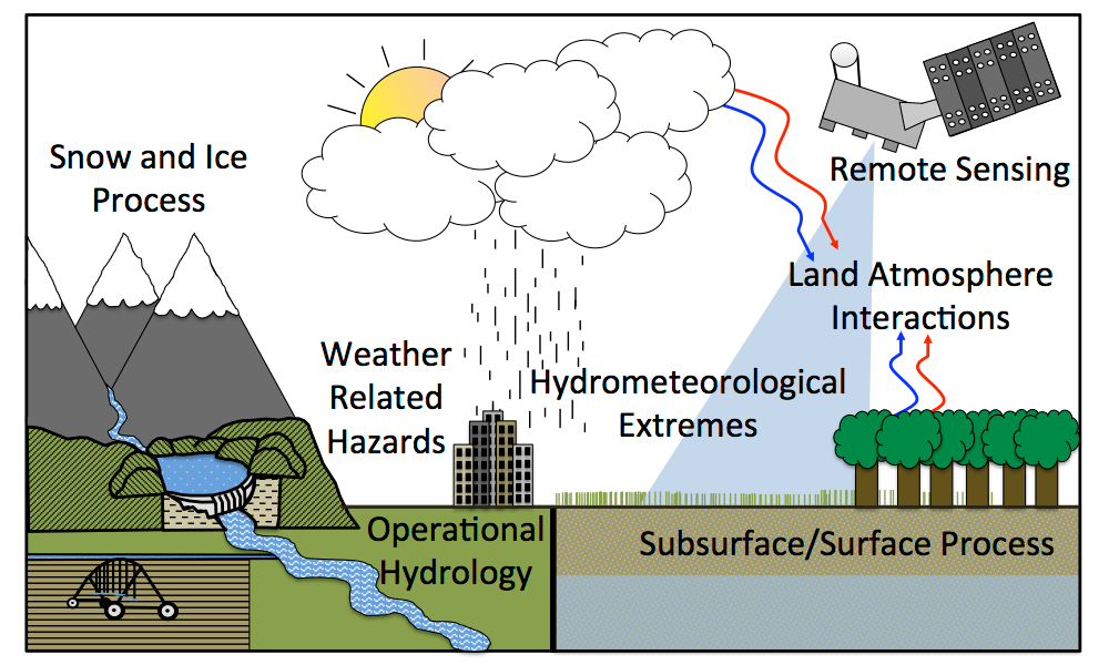
Lab Mission
Our mission is to develop technologies for monitoring and mitigating water hazards, with the aim of reducing their impact on life, the environment, and the economy. For this, we combine physics-based modeling and cutting-edge AI/ML techniques to simulate and investigate the terrestrial water cycle. We focus on developing actionable early warning systems for floods, droughts, and landslides as well as strategies for sustainable water management that can aid the most vulnerable regions of the world.
Major Funded Projects
Indian Land Data Assimilation System (ILDAS)
Effective management of water resources requires reliable estimates of land surface states and fluxes, including water balance components. But most land surface models run in uncoupled mode and do not produce river discharge at catchment scales to be useful for water resources management applications. Indian Land Data Assimilation System (ILDAS) couples land surface models and a hydrodynamic model to estimate land surface states, channel discharge, and floodplain inundation. ILDAS also assimilates remote sensing observations from local and global sources.
Funded by ISRO (2021-24)
BrahmaSATARK – Impact-based Flood Forecasts for the Brahmaputra Basin
Funded in 2023 by the Ministry of Earth Sciences (MoES)/IITM-Pune under Monsoon Mission-III
GBM-CLIMPACT
A climate-impact toolbox for Ganga, Brahmaputra, and Meghna Delta
- Monsoon Mission-III, Ministry of Earth Sciences (MoES), “BrahmaSATARK: A real-time impact-based 2D flood forecasting system for the Brahmaputra River basin using hydrologic-hydrodynamic and statistical-dynamical approaches”, 2020-23.
- DST Indo-Canada IC- IMPACTS, “GBM-CLIMPACT: Development of an end- to-end mod- eling and analysis toolset to assess climate impact and readiness of water sector in the Ganga, Brahmaputra, and Meghna basins”, 2023-25.
- CDRI (Coalition for Dis- aster Resilient Infrastructure), “Detecting Flood Inundation Using Deep Learning and Citizen ScienceFellowship”, 2023-24.
- IIT Delhi Seed Grant,”Development of an Interpretable Machine Learning Framework for Detection and Attribution of Hydrocli- matic Extremes”, 20 Lakhs, 2021-23.
- Principal Scientific Ad- viser to the Government of India, “Establishing a coupled Indian Land Data Assimilation System (ILDAS) for identifying hydrologic extremes”, 2021-24.
- UCL-IITD Strategic Partner Fund,”Making local knowledge matter for landslides and flooding preparedness”, 2020-21.
Research Topics
- Land Surface Modeling
- Radar and satellite precipitation
HydroSense Lab Infrastructure
We provide world-class computational research facilities for all our Masters, PhD, and Postdoctoral scholars from Day 1 of joining our lab.
CPU computing: Majority of our modeling work happens on the IIT Delhi Supercomputer. All lab members have access to generous supercomputing credits to work on their research without any constraints. These credits are purchased using our research grants.
- GPU Workstations: As of Dec 2024, we have 10 high-end Workstations with RTX-4090 NVIDIA GPU.
- Macs: iMac (1), Mac mini (1), iPad Pro (1), 1 iPad Air (1)
- Storage: We have a 12-bay Network Attached Storage (NAS) with 120 TB storage for backup of your research data.
- Accessories: We provide high-end mechanical keyboards, wide monitors, Logitech MX Master mouse, and other accessories.
- Soon to be added: GPU Cluster.
Research Datasets Freely Available
As researchers, we stand on the shoulders of the community. We support open-science by releasing our datasets and code into public domain, except when restricted by source. No co-authorship is expected for using any of these datasets. However, you are welcome to share your research by E-mail. We love hearing about interesting applications!